Today I started to translate Umberto Eco’s new book: Storia delle terre e dei luoghi leggendari – fabulous lands, legendary places, that’s the working title, but the book adds one more twist to what you would expect. It is not simply about imaginary worlds, as we are used to from Eco, from the Baudolino to The Island of the Day Before, but about how the fanatic readers have taken bloody seriously the fictional literary locations from the antiquity to Dan Brown’s Priorate of Sion. And already in the first, ancient chapter we are greeted by our good friends, the meridians.
| Che la terra fosse tonda lo sapeva naturalmente Tolomeo, altrimenti non avrebbe potuto dividerla in trecentosessanta gradi di meridiano, e lo sapeva Eratostene, che nel III secolo avanti Cristo aveva calcolato con una buona approssimazione la lunghezza del meridiano terrestre, considerando la diversa inclinazione del sole, a mezzogiorno del solstizio di primavera, quando si rifletteva nel fondo dei pozzi di Alessandria e di Syene, di cui si sapeva la distanza reciproca. | Of course Ptolemy was also aware that the Earth was round, otherwise he would not have divided it into three hundred and sixty degrees; and this was also known to Eratosthenes, who in the third century BC determined the length of the Earth’s meridian with a good approach, taking into account the different angle of incidence of the sunshine at the time of the spring equinox, when at noon it is reflected in the depth of the wells of Alexandria and of Syene, whose distance was well known. |
Eco, who in his popular albums published in recent years – The Story of Beauty, The Story of Ugliness, The Infinity of Lists – seductively blends trivia with ingenious problem proposals, is like a super jongleur, who plays with a hundred balls at once, and if he drops five, never mind. The translator, however, must also seek for those five, and dust them off, as if they had not fallen. This is what I try now, too.
If at noon the sun is reflected in the depth of a well, it means that it stays exactly perpendicular above the given location. If it is reflected in two, then there is no difference between the two angles of incidence, so nothing can be calculated from it.
The reality is, that the Alexandrian librarian Eratosthenes learned from a caravan arriving from the southern Syene – today Assuan – that the sun is reflected in the depth of the cistern of the settlement, laying precisely under the Tropic of Cancer, in only one day of the year, on June 21, the summer solstice. He thus measured at the same moment the angle of incidence of the sunlight in Alexandria (7°12'), and found it to be the 1/50th part of a full circle, so he concluded that the length of the complete meridian would be fifty times the known distance of the two cities. The resulting circumference of the Earth – 39,690 km – only slightly differs from the 40 thousand known today.
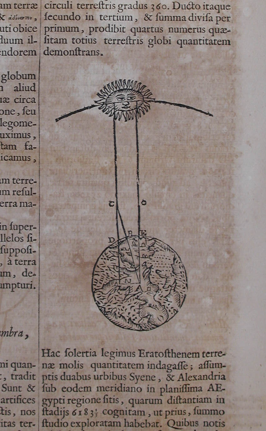
The story of the measurement is well summarized by an English-language interview with Eratosthenes, including a modern diagram. But for the sake of a greater credibility, I quote it from the eccentric baroque Jesuit scholar, Athanasius Kircher himself (Ars magna lucis et umbrae, Amsterdam 1671, 638-639), whose works, as Eco admits, are preserved all (but one) in his personal library.
| Hac solertia legimus Eratosthenem terrenae molis quantitatem indagasse; assumptis duabus urbibus Syene, & Alexandria sub eodem meridiano in planissima Aegypti regione sitis, quarum distantiam in stadijs 6183⅓ cognitam, ut prius, summo studio exploratam habebat. Quibus notis nihil aliud requirebatur, nisi ut eandem distantiâ in gradibus quoque notam haberet, quam ea, qua sequitur solertia invenit. Cùm tempore solstitij Syene urbs sub tropico ♋ immediatè sita, hora meridiana sit ἁσκιη, & umbra in seipsa sine ullo angulo cum gnomone facto consumatur: hoc tanquam cognito, Alexandriae eodem temporis momento dieque gnomonem erexit, diligenter angulum, quem gnomon cum umbra ad verticem faciebat, observando: hic enim erat, ut paulò post demonstrabimus, arcui meridiano inter assumptas urbes aequalis. Sed rem paradigmate demonstremus, etc. | Of Eratosthenes we read how insightfully he measured the extension of the earth, taking two cities, Syene and Alexandria, which lay in the flattest region of Egypt, under the same meridian, and whose distance of 6183 and one third stadiums were previously measured by him with the greatest care. Against this background he did not need anything more than the distance between the two cities in degrees, which he determined in the following ingenious manner. As in Syene, lying immediately under the Tropic of Cancer, on the day of the summer solstice the hour of the noon is ἁσκιη, without shadow, that is, the shadow exactly coincides with the vertical gnomon and does not deviate from it to the least angle, by observing in the same moment in Alexndria the angle of the gnomon to the vertical, he calculated, as we will soon point it out, the angular difference between the two cities. But let’s see the demonstration step by step, etc. |
On the basis of all the above, my translation changed like this:
…and this was also known to Eratosthenes, who, in the third century BC on the day of the summer solstice at noon, when the sun is reflected in the depth of the well of Syene, determined the length of the Earth’s meridian on the basis of the angle of incidence measured in Alexandria, whose distance from Syene was known to him.
Such corrections, dozens per volume, are of course always sent back to the Italian editor, who always say thank for it, and never introduce it in the new editions. Therefore, as we have long known it, an educated European only reads Eco in Hungarian.


 Come with us to…
 Atlantis
 Bestiary
 Bohemia+Prague
 Books, exhibitions, music, film
 Brave old world
 Caucasus
 Cemeteries
 Crimea
 Get to know the
 Images of the East
 Lightwriting
 Lwów/Lemberg
 Mallorca
 Message on the wall
 The Museum of Propaganda
 Odessa
 Paper Museum
 Persian letters
 The Jewish heritage


6 comentarios:
Well, I certainly never intended to start a series of posts on the subject of meridians, but it is indeed gratifying to see it turn into one. I have certainly enjoyed every one of them. And I regret not having time to comment on Catherine's excellent and illuminating post on the subject from a few days back. There was little that could be added, in any event.
One thing, the English-language 'interview' with Eratosthenes that you cite is interesting but claims that Libya is in "South Africa", an incomprehensible error. (Admittedly, it is unimportant to your commentary.)
And if one has to learn Hungarian to properly read Eco in translation, then I'd best get to work. Ad astra per aspera, as they say in Kansas.
Well, you see how in his world map Lybia is much more to the south than Egypt? ;) Maybe he knew the exact length of the meridian, but he had no key to that of Africa…
Ok, I see what you mean in the ancient-world map. The wording led me to think of "present-day" Libya today, not the Libya of Eratosthenes' "present-day".
Well, to tell the truth, the label “Lybia, in South Africa” is mistaken anyway. In Eratosthenes’ “present-day”, Lybia war “the rest of Africa”, and not just the South, and he was born anyway in the north, on the coastline. So, in spite of all my efforts of advocatus diaboli, it must be a simple typo.
So Kansas must belong to one of my imaginary worlds, one of those where they still speak latin, at least to be in connection with some magical constellation …
I don't read Eco in italian anymore, since I have met Rio Wang :-)
(I thought that Per aspera ad astra was Minnesotan slang, anyway)
Publicar un comentario