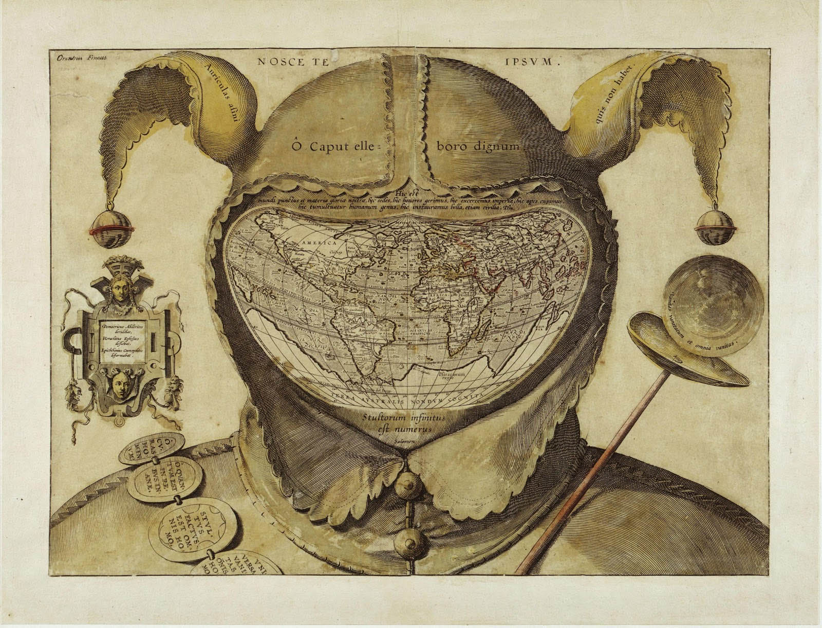
 Stultorum infinitus est numerus — the number of fools is infinite. Map attributed to Oronce Fine, 1590, Bnf.
Of course, everyone knows, that elsewhere, beyond the boundaries of the familiar world, there are people unknown to us, who are both close to us and infinitely strange, and to whom we appear, on our turn, both close and infinitely strange.
Similar and other. Relative and different.
Strangely familiars, of a disturbing relationship.
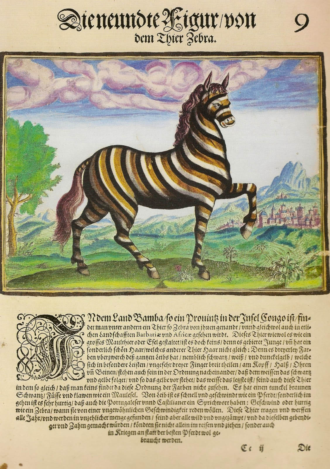 The zebra, Filippo Pigafetta, Frankfurt, 1597
Formerly, before the explorers and discoverers, the unknown stranger who inhabited the imagination of the Europeans, could assume quite unexpected forms, but thanks to God, we rarely encounter them today.

And then the travelers and discoverers came.
The stranger they met wears strange dresses (the strangest of them even do not wear any), he lives in strange places, practice strange occupations, and eat strange foods.

This foreigner often puts on unexpected colors, and sometimes overdoes it to the point of drawing on his own body all kind of lines which will allow him to hide in the jungle, mangrove or bush.

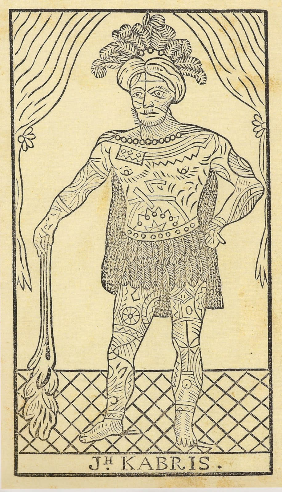 Joseph Kabris, Précis historique et véritable du séjour de J. Kabris, 1817.
The French sailor Kabris was shipwreck in the Pacific Ocean at Nuka Hiva. He just escaped the natives who wanted to sacrifice and eat him. Before marrying the daughter of the king, his body was entirely tattooed so that his skin displays all the ritual symbols of the community, and he is fully integrated in the royal clan. He became a warrior, and participated both in the battles and in the ritual sacrifices and feasting following them. The Russian captain Krusenstern in his circumnavigation stopped at Nuka Hiva, captured Kabris, and in 1804 brought him to St. Petersburg. Having returned to France, Kabris exposed his tattoos at fairs and sold this little booklet. He was thus doubly foreign (and strange), both in Nuka Hiva and upon his return to Bordeaux.
This was a time of curious and fearless travelers, those traveling with painters and botanists, cartographers and naturalists, Bible, porters and interpreters. The travelers were very rare, but their stories exciting and the readers passionate.
Most of these readers never traveled far, and even in the 20th century the lovers of dreams plunged into the books with the eyes of imagination.
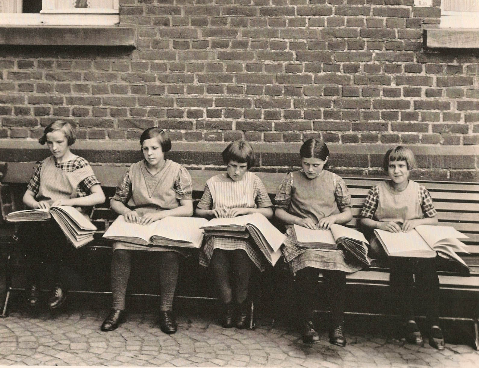 August Sander, Blind children, 1931.
Every day I go to work by taking line 8 of the metro of Paris.
Line 8 is the longest of the network, it parts from the south of the 16th district in the uptown west of the capital, goes down to the business districts, and then, following the great boulevards, it reaches the still popular streets of the 11th district, connecting the symbolic places of the revolutionary Paris of 1789 and 1848, the République, Chemin Vert, Bastille, Ledru-Rollin – which have also been the places of immigration for more than a century –, descends to the Forest of Vincennes, and, through the south-eastern suburbs, it reaches the town of Créteil and its 90 thousand inhabitants from all backgrounds.
Before 8 o’clock in the morning there are around me all those sleeping men and women with dark skin, returning from the night cleaning in the offices of western Paris. Later, all those readers of mysterious letters, opening newspapers printed, we imagine, in Bangkok, Dhaka, Fuzhou, Addis Ababa. In the afternoon, it is the old Africans telling their beads, with a black parka over their dress embroidered with so many shades of blue; Chinese women loaded with bags, who fall asleep just sitting on the corner of the back seat, and whose age is impossible to guess; the old woman turning the pages of a Romanian book, more and more worn from week to week, imaginably the only one she has; the young girls returning from the University of Créteil and discussing with loud words and laughter about their law course; and the hilarious young people whose jokes fly over the heads of the passengers in the language of the films of Satyajit Ray. And there are still all these pious readers, those who turn the pages of their Quran, their lips always moving, those who read evangelist brochures with pencil in hand, and the Polish ladies who mark their page with a holy image before leaving the train.
I should also tell about all the little children of the last fall, falling asleep early in the morning on the benches and folding seats, their bags between the legs, their mothers dormant at their sides, the faces of children coming from elsewhere, living in some “social housing project” in the agglomeration of Paris, never for long time in the same one, and going to school where they arrived at the beginning of their wandering. Like this little boy, perhaps Chechen, not more than five, frantically asking his mother in Russian, in soundbites full of tears, and she stubbornly replying in French, in a smashed and stammering French, but firm in her demands for his first day in the class.
And a few stray tourists, by the way also foreigners, their hands on the sacs, alert eyes.
On line 8, outside of Paris, the metro leans dangerously once in one direction – porte Dorée –, then in the other – porte de Charenton –, and the wheels squeal in a deafening hiss, when it resumes speed towards station Liberté. In the corner marked by these three stations as a fold of the line, just above these travelers coming from around the entire world, in 1931 extended the Colonial Exhibition.

When crossing today the part of the Forest – or rather park – of Vincennes where the exhibition was held, one seeks long the traces. Towards the lake, where the “native rowers” paddled in the mown lawn, where the dogs of the neighborhood were running around, the copy of a palace of Cameroon became “the Pagoda of Vincennes”, a Buddhist monastery. Porte Dorée: a concrete panel covered with greenish lichen commemorating since 1931 the exploration of Africa. Opposite, the Palace of Porte Dorée, still exposing the reliefs on the facade and the frescoes in the hall of entrance. That’s all.

Since 2007, the Palace of Porte Dorée has become the “National city of the history of immigration”. The building was erected on the occasion of the Colonial Exhibition of 1931 by the French architect Albert Laprade, to provide a summary of the history, economy and arts of the French Empire. It housed first the permanent Museum of the Colonies, renamed Museum of Overseas France in 1935, and becoming after the decolonization Museum of African and Oceanic Art in 1960. The museum was closed down in January 2003, when its collections were united with those of the Museum of Man to form the Museum of First Arts at Quai Branlay.

Inside, in the hall of entrance, a complex fresco by Pierre-Henri Ducos de La Haille.
A museum of immigration which does not speak about colonization, not even to mention the history of the place which accepts the visitor, but which has kept all its former decor – to the aquarium in the basement, which was also established in 1931, and which was for a long time the largest one in Paris.
In the box in the lobby I ask for a ticket. The attendant:
“To the aquarium?”
“No, to the immigration.”
“Ah? The immigration?…”
It is a museum that welcomes few visitors. In the three rooms on the top floor it presents a collection of official documents and photos together with a few items left by families (a sucase, a passport, a boat ticket, the first contract of work, some images from the past). It is mainly visited by high school students with their teachers, students most probably coming from the suburbs with line 8.
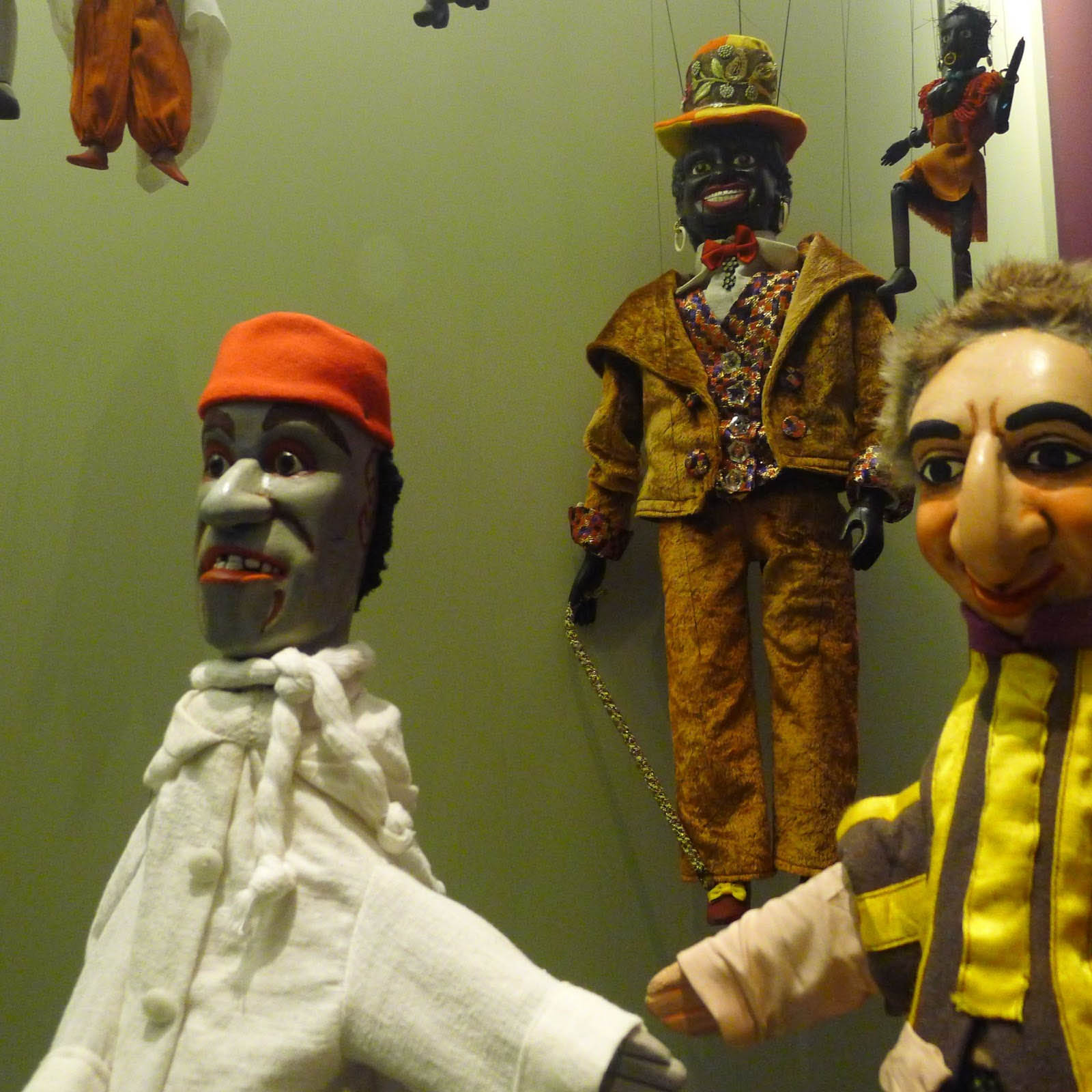 The windows of puppets (string or glove):
 “the black woman”, thirties; “the black man” and “the arab”, early 20th century; “the Jewish usurer”, late 19th century
An exact contemporary of the Exhibition of 1931, a volume of the Larousse Encyclopaedia provides a description of the various populations of the globe, incuding Europe, which surprisingly blends this curious spirit of the travelers of the previous century (palpable in the choice of some great pictures) with a post-Darwinian discourse on the adaptation of the races to various natural environments, giving way to a complex taxonomy of mankind. The author, professor and paleontologist of the Natural History Museum, in his introduction mixes up with an easy hand apes, prehistoric populations and contemporary primitive peoples, sorts and classifies the various populations of the world, pointing out the educative mission of France, to celebrate in conclusion that the “most backward” people have already made “significant progress”. The whole comprises nearly 700 photos and drawings, including a large part from the collections of the Natural History Museum or that of the Museum of Man, dating from the late 19th and early 20th century.


Once they said about someone born in the same village – or really in the immediate proximity – that he was un pays, a “countryman”. Sometimes, during the adventure of a trip to the capital, in the middle of the crowded streets, one had the pleasure of meeting a “countryman”. From the perspective of this familiar formula, the others were always strange foreigners.
Not long ago in a village I know I heard of a woman who had lived there for years and had raised her children, but who was born in a village a few kilometers away, that she was a foreigner. Her husband himself said: “I married a foreigner.” Between the two villages there passes an impassable mental border, the one separating Burgundy from Champagne (and over there, they are absolutely not like we are!)
There are no foreigners without frontiers, and there are no frontiers without papers to cross them. Papers that monitor you, papers that file you, papers that track you down – but also papers that make you free, papers that let you travel, papers that allow you to work.
Papers which give you rights, rights to work, rights to a family life, rights to movement, rights to organize and express yourself – and perhaps also the rights to vote, one day soon.


 Atlantis
 Bestiary
 Bohemia+Prague
 Books, exhibitions, music, film
 Brave old world
 Caucasus
 Cemeteries
 Crimea
 Images of the East
 Lightwriting
 Lwów/Lemberg
 Mallorca
 Message on the wall
 The Museum of Propaganda
 Odessa
 Paper Museum
 Persian letters


