
I am obsessed with maps. I have been collecting them since my childhood, in all languages, editions and scale, from every place to where with more or less likeliness I want to get in this life, which, apart from the land of eternal ice and high deserts roughly covers the globe.
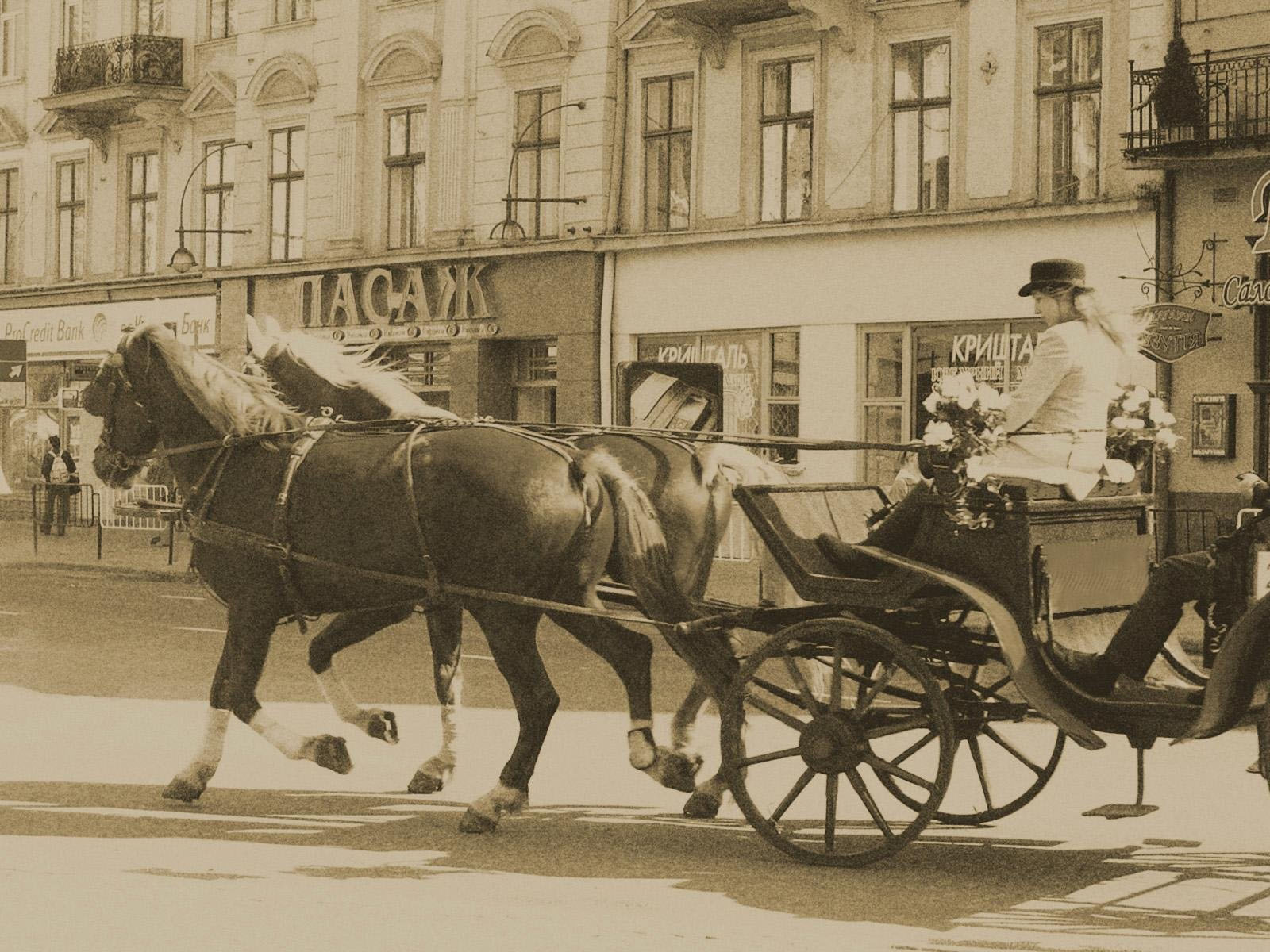
For years I have traveled with companies using GPS, but I, to be on the safe side, always bring my maps with me. And never in vain. During the last tour to Lwów it happened that, incredibly, from Uzhgorod to Lviv and Tarnopol to Ivano-Frankivsk I, the guide was the only person on the bus, including the bus drivers, who had a map of Ukraine and of the cities visited. “Sir, you started in the opposite direction”, I warned them at the Łyczakówski cemetery. “It is not possible, for the GPS shows this!” At the open air museum of wooden churches the GPS showed a route for buses where the street was long built in, and a main route where there was a one-way street coming from the opposite direction. Nevertheless, with the help of maps, by inquiring local people in local languages, or by resolutely closing off the one-way street for a short while everything could be solved. I only left the group for one single evening to take a beer with my friends: we arrived back to the hotel earlier than the bus, because the driver, in defiance of the beaten path, relied on the GPS, and finally managed to arrive back only when, already roaming outside the administrative borders of Lwów, Andrea finally listened to the voice of the common sense and took a taxi which led them to the hotel.
After Lwów, however, an unexpected thing happened. Bumbó, who is nosing the waves of ether from the main-top of Telecom in Kőbánya, has sponsored with a GPS our Eastern European heritage tour. Thus the mapping of the route of Jewish wine from the Hungarian Tokaj to Polish Nowy Sącz was also a test of modern technology. And what a test! The GPS has led us safely through the Vranov-Bardejov mountains, along such roads which we would have not dared to turn to even in daytime, while in bright day it led us against a concrete wall in the downtown of Zvolen, and made us a ten-kilometer detour along the Banska Bystrica – Šahy main road, which we otherwise know as the palm of the hand, and just followed the instructions of the GPS to see the extent of its autonomy defying the facts.
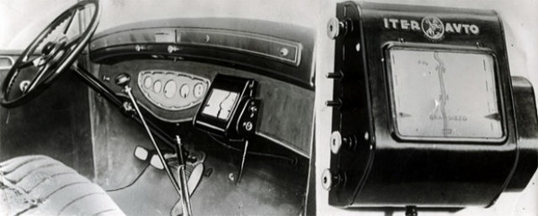
Our conclusion, that it is still the best to fill out with paper-based maps the lacunae of the quasi-infallibility of the GPS, is reinforced by the proof of the first occurrence of GPS technology – from 1932. The device was developed by the Touring Club Italiano, which has been always the best in the documentation of the Italian road network, and its regional guides still outperform the best German baedekkers. Of course, the device was not yet based on satellite, but one had to insert the proper paper roll in it, and this, by turning in consonance with the speed of the car, showed the approximate position and direction.

After the publication of this post Giacomo Ponzetto has drawn our attention to an advertisement of this proto-GPS just for sale on ebay (dated at “about 1950”, but as the device is advertised as a recent invention, therefore it must be rather of early 1930s, as its typography also attests it).

| La Fiera Campionaria di Milano ha visto quest’anno il trionfo di una manifestazione della genialità e della intelligenza italiana! Tecnici, amatori, sportmans [sic!] hanno tutti lealmente riconosciuto e vantato la praticità e l’utilità dell’
„Iter-Auto”
elegante e pratico indicatore stradale che ogni automobilista sentirà la necessità di applicare con rapida e semplice operazione al cruscotto della propria macchina!!!Automobilisti, l’Iter-Auto è il vostro Santo Protettore in terra che vi guiderà per mano nei vostri viaggi mostrandovi con esattezza impeccabile, a mezzo di una cartina-itinerario svolgentesi in perfetto sincronismo con la marcia del vostro automobile, la via da percorrere nonchè tutti quei dati e quelle indicazioni pratiche di continua necessità come: Bivi – Ponti – Cunette – Passaggi a livello – Svolte pericolose – Rifornimenti – Soccorsi – Garages – Alberghi ecc. consigliando in tempo utile (circa 3 km. prima) il conducente al necessario rallentamento dinanzi al pericolo. Non più fermate per scrutare tabelle spesso illeggibili o consultare carte incomode e sovente indecifrabili al profano. Non più panne per mancanza di carburante. | The Trade Fair in Milan this year has seen the triumph of a manifestation of Italian genius and intelligence! Technicians, amateurs, sportsmen all have fairly recognized and claimed the practicality and usefulness of
„Iter-Auto”
an elegant and practical motorway guide which each driver will feel the need to implement in a quick and easy step to the dashboard of his car!!!Motorists, the Iter-Auto is your Patron Saint on earth who will guide you by the hand in your travels, showing with impeccable accuracy, by means of a route-map turning on in perfect sync with the progress of your car, the way ahead as well as any practical data or information of continuous need, such as: Junctions – Bridges – Bumps – Level crossings – Dangerous turns – Fuel stations – Aid stations – Garages – Hotels etc. advising the driver on time (about 3 km. before the danger) to slow down. No more stopping to peer at the often illegible guideposts or check inconvenient maps which are often indecipherable to the layman. No more breakdown due to lack of fuel. |

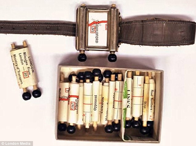
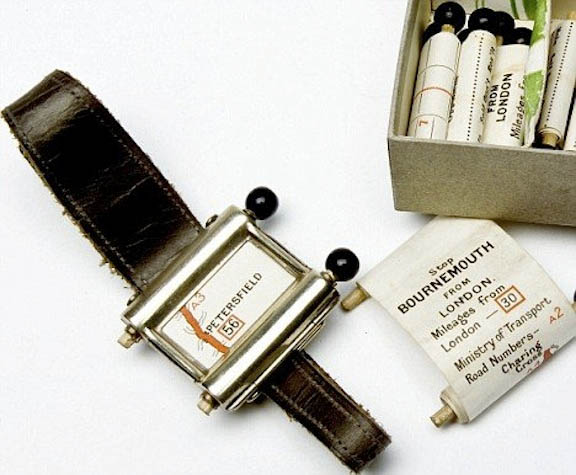
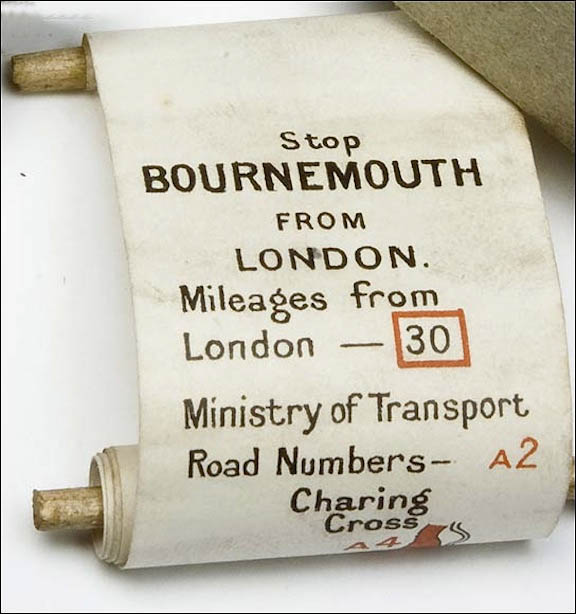
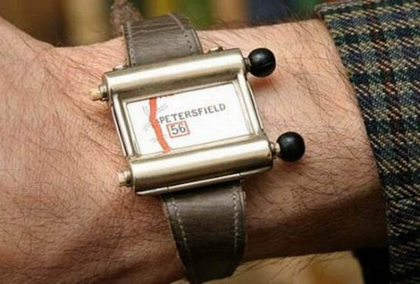
Unfortunately we could not find anywhere on the web any rolls for the device, but the feeling can be made up by that British wrist-watch-GPS of 1927 to which several regional rolls can be purchased at auctions until now. The only downside was that the driver himself had to spool on the paper roll from time to time.
We can only guess why this technology did not develop further and triumphed throughout Europe. To be sure, its spreading would have required the development of the communication network along the roads, by making available the proper rolls at any point where the driver might have wanted to change direction, and concerning this, Italy lagged far behind Germany even in the Mussolini era, not to speak about later times. It is also likely that the comprehensive Italian mind required a much larger overview than what the proto-GPS worming ahead meter by meter could offer, and this led ultimately to the publication of the unbeatable volumes of the Atlante Stradale d’Italia. These volumes, by the principle of the golden mean, point at the same fact with which I have started this post: that how indispensable are, even in the era of GPS, the accurate, good and beautifully drawn maps. Which, if I have not yet said, I am obsessed with.


 Come with us to…
 Atlantis
 Bestiary
 Bohemia+Prague
 Books, exhibitions, music, film
 Caucasus
 Cemeteries
 Crimea
 Get to know the
 Images of the East
 Lightwriting
 Lwów/Lemberg
 Mallorca
 Message on the wall
 The Museum of Propaganda
 Odessa
 Paper Museum
 Persian letters
 The Jewish heritage


5 comentarios:
oh, but we already knew about your obsession: what Rio Wang is, if not a map of many worlds?
Please, le me know where is the wonderful incipit of your post from.
It was an anonymous commentary to a Hungarian article on the future of e-books. I liked it and have saved it for myself; and did it well, because since then its original has disappeared from the web.
An advertising brochure for the Iter-Auto is currently being sold on eBay. The front page is clearly readable:
ITER-AUTO
Società Anonima
Via Due Macelli, 31 - ROMA - Telefono n. 63-339
San Cristoforo San Giorgio
La Fiera Campionaria di Milano ha visto quest'anno il trionfo di una manifestazione della genialità e della intelligenza italiana!
Tecnici, amatori, sportmans hanno tutti lealmente riconosciuto e vantato la praticità e l'utilità dell'
"Iter-Auto"
elegante e pratico indicatore stradale che ogni automobilista sentirà la necessità di applicare con rapida e semplice operazione al cruscotto della propria macchina!!!
"Automobilisti, l'Iter-Auto" è il vostro Santo Protettore in terra che vi guiderà per mano nei vostri viaggi mostrandovi con esattezza impeccabile, a mezzo di una cartina-itinerario svolgentesi in perfetto sincronismo con la marcia del vostro automobile, la via da percorrere nonchè tutti quei dati e quelle indicazioni pratiche di continua necessità come:
Bivi - Ponti - Cunette - Passaggi a livello - Svolte pericolose - Rifornimenti - Soccorsi - Garages - Alberghi ecc.
consigliando in tempo utile (circa 3 km. prima) il conducente al necessario rallentamento dinanzi al pericolo.
Non più fermate per scrutare tabelle spesso illeggibili o consultare carte incomode e sovente indecifrabili al profano.
Non più panne per mancanza di carburante
Thank you, Giacomo! It is a marvelous completion of the post, which came just in time. I have now included it in both versions of the post, together with the English and Hungarian translation, respectively.
Does anyone know what price the Iter-Auto brochure fetched on Ebay? I'd love to get hold of one! If the buyer is reading this, I'd very much like to know if it might be for sale again… or failing that, a good scan would be great...
Publicar un comentario