Switch over to our new blog! • ¡Pásese a nuestro nuevo blog!

The renewed version of our blog, with more features, a richer design, and available in nine languages, can be read here: https://wangriver.com

The new version also includes the old posts, often in expanded form. If you are curious about the updated version of this post, replace “riowang.blogspot.com/” in the URL with “riowang.studiolum.com/”, and the new link will most likely lead you there.


La versión renovada de nuestro blog, con más herramientas, un diseño más rico y disponible en nueve idiomas, se puede leer aquí: https://riowang.com

La nueva versión también incluye las publicaciones antiguas, a menudo en una forma ampliada. Si tiene curiosidad por la versión actualizada de esta entrada, sustituya «riowang.blogspot.com/» en la URL por «riowang.studiolum.com/es/», y el nuevo enlace probablemente le llevará allí.

Mostrando entradas con la etiqueta Julfa. Mostrar todas las entradas

El cementerio armenio de Julfa


Mientras el estado iraní remoza las iglesias armenias del norte de Irán y las propone para engrosar la lista del Patrimonio Mundial de la UNESCO, unos cien metros más allá, al otro lado del río que marca la frontera, se hace todo lo posible para que desaparezcan sin dejar ni rastro.


El río Aras es frontera desde 1828, cuando la expansión del imperio ruso conquistó el norte de Azerbaiyán, y luego Armenia, a Persia, donde había estado integrada durante dos milenios y medio. La nueva frontera partió en dos la ciudad de Julfa, que se extendia por ambas riberas del río, unidas por el puente de piedra al que cantó Virgilio —pontem indignatus Araxes—. Por entonces, con todo, la ciudad ya ni recordaba su edad de oro, cuando fue el principal enlace comercial entre Persia y Europa.
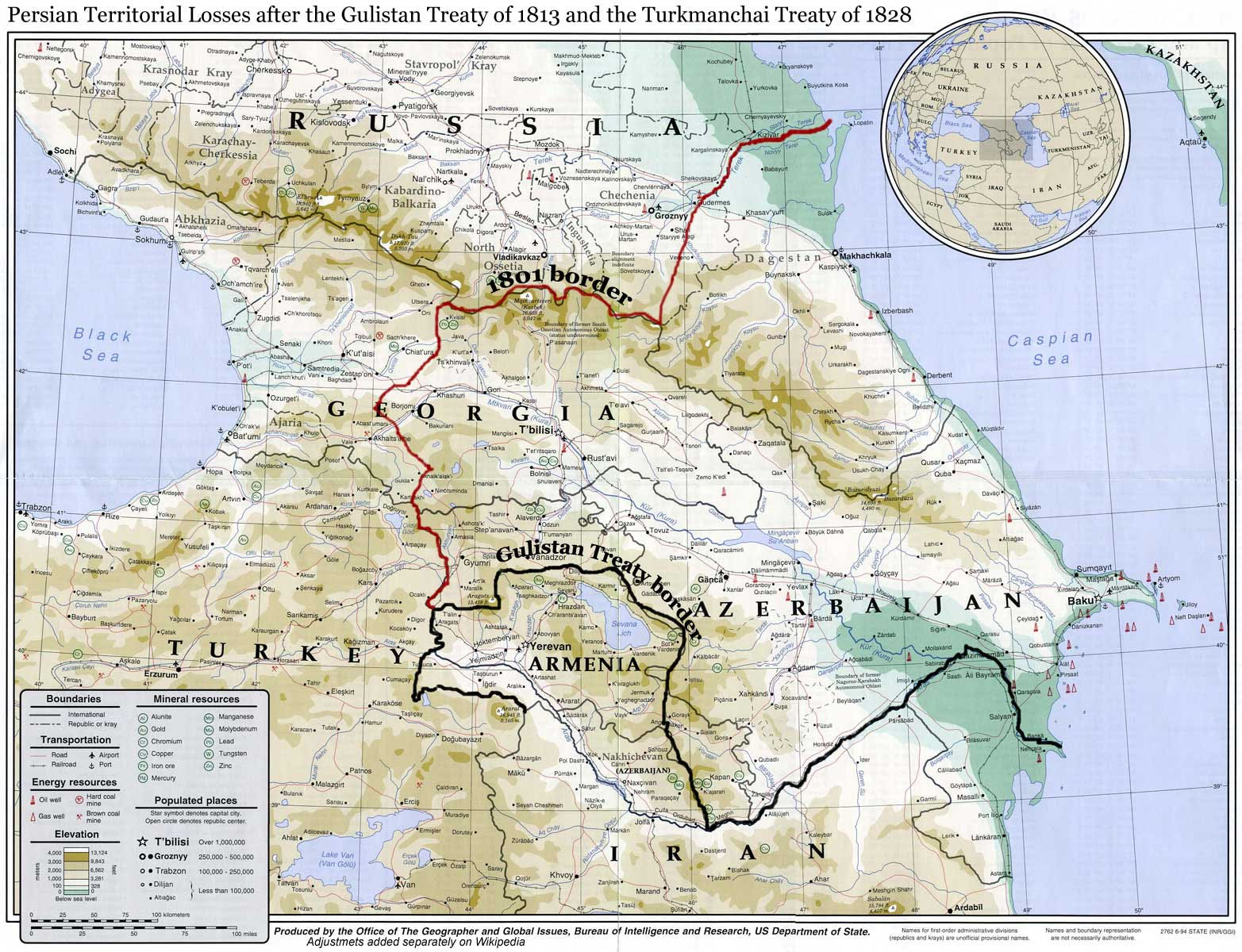
El mapa de Wikipedia marca en negro la frontera de 1813. La frontera oficial desde 1828 es prolongación de la anterior, siguiendo el Aras a lo largo del borde sur de Armenia.

En el siglo XVI los comerciantes armenios de Julfa eran compradores de seda cruda, el producto más preciado de Persia, y desde allí lo repartían a toda Europa. Mantenían casas comerciales de Alepo a Amsterdam, pasando por Venecia. Los viajeros europeos describían Julfa como una ciudad asombrosamente rica, con siete iglesias y tres mil casas de piedra. La opulencia de la ciudad la atestiguaba sobre todo su cementerio, donde se llegaron a contar hasta diez mil khachkars, tumbas del tamaño de un hombre diestramente talladas en piedra.


La edad de oro de Julfa terminó de golpe. Durante las guerras turco-persas de fines del siglo XVI, el Sha Abbas el Grande advirtió rápidamente que en aquella zona de frontera abierta al imperio otomano no iba a ser capaz de defender la ciudad, auténtica gallina de los huevos de oro. Y así, en 1604 toda la población de la provincia armenia de Nakhichevan fue trasladada a marchas forzadas —unas cien mil personas murieron por el camino— hasta varios cientos de kilómetros al sur, a Isfahan y sus alrededores. En Isfahan los comerciantes armenios hicieron florecer Nueva Julfa, que hoy pervive todavía como barrio armenio, y fueron también las manos de los artesanos armenios las que hicieron de la plaza principal de Isfahan una de las maravillas del mundo. La vieja Julfa de Nakhichevan jamás se recobró. Sus ruinas aún pueden observarse al oeste de la pequeña ciudad que hoy lleva su nombre. Solo el cementerio permaneció intacto en el extremo occidental de la ciudad devastada, sobre el banco del río, con diez mil tumbas de piedra labrada primorosamente.

El cementerio de Julfa hacia 1910 visto desde el oeste. La ciudad estuvo antaño en la margen izquierda del Aras, en la falda de las montañas. En la margen derecha del río, la ribera iraní, sobre una peña todavía permanece la pequeña iglesia armenia conocida como «Iglesia del Pastor» (Kelisâ-ye Chupân) erigida en 1518. Abajo puede verse la foto probablemente más antigua del del cementerio, tomada por B. Chantre: A travers l'Arménie russe (París, 1983), procedente de aquí.

Julfa, örmény temető, B. Cantre fotója, 1893
El nombre de Nakhichevan significa en armenio «Lugar del descenso»: Noé, sus hijos y todos los animales de la tierra se apearon aquí del Arca recién atracada en la cima del cercano monte Ararat. Fue provincia puramente armenia hasta 1604, cuando la gran emigración. El lugar de los armenios deportados fue ocupado por tribus de pastores turcos y, más tarde, el Sha enviaría allá también tribus turcas para defender las fronteras. Desde entonces, los armenios que consiguieron permanecer, más aquellos que volvieron furtivamente, sumaron una insignificante minoría respecto a los azerís turcos. En 1920, el territorio se anexionó hasta Azerbaiyán, como provincia autónoma. En 1979 solo quedaba allá un 1,4% de armenios, donde un siglo antes llegaron al 40% de la población. Tras la guerra de Karabaj desapareció incluso este último resto. Solo quedó el cementerio.


Las primeras fotos del lugar —treinta y ocho— fueron tomadas en 1928 por Jurgis Baltrušaitis, el famoso historiador del arte (La Edad Media fantástica), poeta y embajador de Lituania en la Unión Soviética: es el testimonio gráfico más completo del cementerio en un territorio de frontera estrictamente controlado por el ejército soviético. Sus fotos se publicaron en Lisboa (gracias a la fundación Calouste Gulbenkian), acompañadas de un texto de Dickran Kouymjian, en 1986. Todo ello puede descargarse en pdf de la web djulfa.com, dedicada al lugar.

Una de las fotos de Baltrušaitis

El último en ver el cementerio fue el arquitecto escocés Steven Sim, en agosto de 2005. Mientras visitaba los monumentos armenios de Nakhichevan se encontró con que todas las iglesias medievales armenias de la provincia habían sido arrasadas, y solo debían haber pasado dos o tres años, pues sobre las ruinas apenas había crecido vegetación. Sin embargo, todavía pudo ver el cementerio de Julfa intacto desde el tren que corre a lo largo del cauce del río. Los guardias del tren le prohibieron sacar fotos, y más tarde acabarían arrestándole y expulsándole del país.


Mientras paseaba por Irán y me acercaba a los monumentos armenios desde el sur, pensé que en mi próximo viaje yo también iría allá, cruzaría el puente y fotografiaría aquellas tumbas. Demasiado tarde. El cementerio de Julfa fue destruido justo el día de mi 40 aniversario. Es inquietante pensar que mientras un grupo internacional de amigos me sorprendían con vinos italianos y españoles, el ejército azerí en la ribera del río Aras estaba reduciendo a polvo uno de los monumentos más ricos de la cultura armenia y cargando los escombros en camiones, aquellos días 15 a 17 de diciembre de 2005. La destrucción fue grabada desde el lado iraní del río por los armenios locales. El vídeo de abajo lo montó Sarah Pickman a partir de aquellas imágenes, y también ella fue la primera en notificar los hechos a Archaeology.


El Parlamento Europeo condenó la destrucción en una resolución de 16 de febrero de 2006 y propuso enviar una delegación a la zona, iniciativa hasta ahora obstaculizada por el gobierno azerí. «Mentira y provocación», declaró el presidente azerí, Ilham Aliev. «Ningún monumento armenio ha sido destruido, pues nunca ha habido armenios en Nakhichevan».
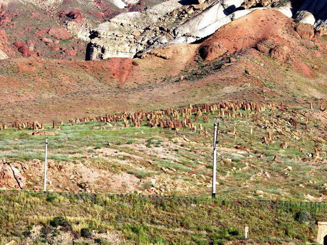

Los miembros azerís y de Nakhichevan del Institute for War and Peace Reporting publicaron el primer reportaje rápido en abril de 2006, donde daban cuenta de la absoluta destrucción del cementerio. Un campo de tiro militar ha sido instalado en aquel lugar.


La memoria de los khachkars ha sido preservada por el Djulfa Virtual Memorial Museum.


Hasmik Harutyunyan: Canción de cuna de Tigranakert (5'53"). Del álbum Armenian Lullabies (2004)

The Armenian cemetery of Julfa


While the Iranian state renovates the Armenian churches in Northern Iran and submits them to the World Heritage List of UNESCO, some hundred meters further on, on the other side of the boundary river they do everything so that theirs disappear without a trace.


The Araxes became a boundary river in 1828, when the expanding Russian Empire conquered Northern Azerbaijan, and then Armenia from Persia, to where they had belonged for two and half millenaries. The new frontier cut in two the town of Julfa laying on the two banks of the river, at the stone bridge which had been sung of – pontem indignatus Araxes – also by Virgil. At this time, however, the town did not even remember its golden years when it had been the main hub of commerce between Persia and Europe.

The map of Wikipedia traces in black the boundary of 1813. The official boundary since 1828 is the prolongation of the former one, following the Araxes along the southern border of Armenia.

In the 16th century the Armenian merchants of Julfa were the buyers of row silk, the most precious product of Persia, and it was delivered by them to all Europe. They had commercial houses from Aleppo through Venice to Amsterdam. European travelers described Julfa as an astonishingly rich town with seven churches and three thousand stone houses. The richness of the town has been attested most of all by its cemetery where ten thousand beautifully carved, man-high tomb stones, khachkars have been counted.


The golden years ended abruptly. During the late 16th-century Turkish-Persian wars Shah Great Abbas has soberly gauged that in the frontier zone open to the Ottoman Empire he would not be able to defend the town, this goose laying golden eggs, and therefore in 1604 had the complete population of the Armenian province of Nakhichevan moved in a forced march – a hundred thousand people died on the way – several hundred kilometers southward, to Isfahan and its confines. There Armenian merchants have made flourish the still today Armenian suburb of New Julfa, and the hands of Armenian masters converted the main square of Isfahan into one of the wonders of the world. Julfa in Nakhichevan has never recovered. Its ruins still can be observed to the west of the little town bearing its name today. Only the cemetery has remained intact at the western end of the ruined town, on the river bank, with ten thousand beautifully carved tomb stones.

The cemetery of Julfa around 1910 seen from the west. The town once stood on the left bank of the Araxes, at the feet of the mountains. On the right, Iranian bank, on the top of the rock at the riverside still there is standing the small Armenian church called “Shepherd Church” (Kelisâ-ye Chupân), built in 1518. – Below you see the probably oldest photo of the cemetery from B. Chantre: A travers l’Arménie russe (Paris, 1893), from here.

Julfa, örmény temető, B. Cantre fotója, 1893
The name of Nakhichevan means in Armenian “the place of the descent”, for it was here that Noah, his sons and all the animals of the earth descended from the Arch which had stranded on the top of the nearby Ararat. It was a pure Armenian province until 1604, the great migration. The place of the deportated Armenians was occupied by Turkish population. The shah sent later some more Turkish tribes here for the defence of the frontiers. Since then the Armenians who remained there and those gradually sneaking home have remained in minority in respect to the Azeri Turks. In 1920 the region was annexed to Azerbaijan as an autonomous province. In 1979 only 1.4% Armenians lived there, where a century earlier they were 40% of the population. After the Karabagh war even they disappeared. Only the cemetery has remained.


The first photos – thirty-eight – were made in 1928 by Jurgis Baltrušaitis, the great art historian (“Le Moyen-Âge fantastique”), poet and Ambassador of Lithuania in the Soviet Union. It has remained the most detailed photo documentation of the cemetery laying in this severely controlled frontier zone of the former Soviet empire. His photos were published with accompanying text by Dickran Kouymjian in 1986 in Lisbon. Its PDF version can be downloaded from the djulfa.com site dedicated to the cemetery.

Photo by Baltrušaitis

The last one who saw the cemetery was the Scottish architect Steven Sim in August 2005. While visiting the Armenian monuments in Nakhichevan, he found that all the medieval Armenian churches of the province had been completely destroyed, and only one or two years earlier, because their fresh ruins were not yet covered by the vegetation. However, he still found the cemetery of Julfa intact as the train passed by it on the river bank. The train guards prohibited him to take photos of it, and later he was even arrested and expelled from the country.


While wandering in Iran and approaching the Armenian monuments from the south, I thought that on my next journey I would also cross the bridge and take photos of the tombs. I came too late. The cemetery of Julfa was destroyed precisely on my 40th birthday. It is strange to consider that while an international company of friends was celebrating in our house and my friends surprised me with a show of Italian and Spanish wines, the Azerbaijani army on the bank of the Araxes was just smashing to pieces one of the richest monuments of Armenian culture, carrying away the fragments by lorries from 15 to 17 December in 2005. The destruction was videotaped from the Iranian side of the river by local Armenians. The video below was made on the basis of their recordings by Sarah Pickman, who was also the first to report on the events in Archaeology.


The European Parlament condemned the destruction in a resolution on February 16, 2006, and wanted to send a delegation to the place, which has been hitherto prevented by the Azerbaijani government. “Lie and provocation”, declared Azerbaijani president Ilham Aliev. “No Armenian monuments were destroyed, for never any Armenians lived in Nakhichevan.”


The Nakhichevan and Azeri members of Institute for War and Peace Reporting published the first spot report in April 2006, in which they rendered account of the complete destruction of the cemetery. A military shooting range was established on its place.


The memory of the khachkars has been preserved by the Djulfa Virtual Memorial Museum.


Hasmik Harutyunyan: Lullaby of Tigranakert (5'53"). From the album Armenian Lullabies (2004)

Armenian monasteries in Iran

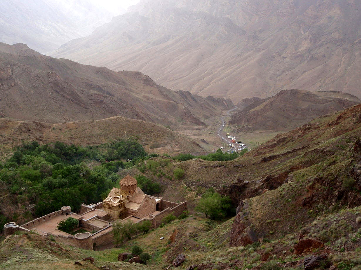
The medieval Armenian monastery of Saint Stephen in Northern Iran, in the valley of the Araxes/Aras
More Armenian posts:
The Armenian cemetery of Julfa
Lake Van, the legend of Ara
“Russian first”
The excellent Días del futuro pasado blog gives news with images and drawings borrowed from the site of UNESCO about a group of monuments we especially love having recently been included on the list of World Heritage. Three monumental medieval Armenian fortified churches among the majestically barren northern Iranian mountains, the monastery of Saint Thaddeus, the monastery of Saint Stephen and the Dzordzor chapel. The map taken from armenica.org only indicates the two larger ones, the chapel was localized on it by ourselves.

Map: three medieval Armenian monasteries on the list of the UNESCO World Heritage
All three sanctuaries lay in unpopulated valleys and have been abandoned since times immemorial. A monastery used to stand along the chapel as well, but it perished long ago. The environs are inhabited by Kurd and Azeri herdsmen and peasants. No Armenians live around here. One could regard it surprising to find so far from Armenia and among a foreign and Muslim population three monasteries so large that they would be considered noteworthy even in Armenia. But only as long as he does not know that not the monasteries were built far from Armenia, but it was Armenia that moved far away from them.

Map: The changing borders of Armenia in the past two thousand yearsThe changing borders of Armenia from around the birth of Christ until our days, from the Armenian historical atlas. We have marked the place of the three monuments with a red Armenian cross.

The map clearly shows that the monasteries were built on the central part of historical Armenia, in the Vaspurakan region to the east of Lake Van, which in the Middle Ages was also an independent kingdom for some centuries. This was the cradle of the Armenian people, a rich region, crossed by several caravan routes. At its eastern border lays Tabriz, the gate of Eastern commerce in the times of Marco Polo, and above it, on the side of the mountain river Araxes/Aras the Armenian town of Julfa which played a key role in Persian silk commerce and in the age of the Renaissance it also had its own commercial representation and Armenian colony in Amsterdam.

The church of St. Stephen on the side of the Araxes/Aras riverJulfa, the old Armenian church at the Araxes river

The reason of the destruction of this region and of historical Armenia was that from the end of the Middle Ages it laid on the periphery of three great powers. None of the three was strong enough to occupy and also maintain the Armenian territories like ancient Persia and later Byzantium did, but all the three had fear that it could serve to the other two as an area of supply and as an eventual ally in case of an offensive. Therefore all the three kept systematically depopulating it for centuries. The Persian shah Great Abbas resettled in 1606 the almost complete Armenian population of the territory under his dominion, including that of the town of Julfa, to his new capital Esfahan where their descendants still live in the Armenian quarter New Julfa. Two centuries later the Russians conquering the Caucasus settled in the internal parts of their country the Armenian merchants from the occupied territories. And during the First World War it was the Turks who, having fear of an eventual expansion of the Armenian province under Russian rule, definitely extirpated the more than one million Armenian inhabitants of historical Armenia. Where Xenophon, during his withdrawal with the Spartan army, but even the Hungarian discoverer Ármin Vámbéry wandering from the Black Sea to Tabriz, passed along a series of Armenian villages, the modern traveler only sees sublime mountains and deserted platos, for after 1915 the Turkish state systematically obliterated even the depopulated Armenian settlements and medieval churches.

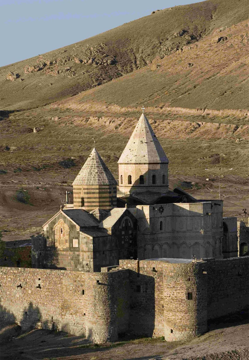
The medieval Armenian monastery of Saint Thaddeus in Northern Iran
The monastery of Saint Thaddeus was built according to the tradition by the Apostle Saint Judas Thaddeus, “the brother of the Lord” and the first missionary of the Armenians in 66 A.D. According to the fifth-century Armenian chronicler Movses Khorenatsi, he is also buried here. If this is really so, then this church is equal in rang with the Roman basilicas of Peter and Paul, the tomb in Compostela of the Apostle Jacob, and the Madras cathedral of the Apostle Thomas, only much less known. It was rebuilt in 1324 after an earthquake, and because of its black and white stones local people call it with a half Azeri, half Persian name Qara Kelisa, Black Church. You can find a detailed description, many good images and drawings of it at armenica.org.

The medieval Armenian monastery of Saint Stephen in Northern Iran, in the valley of the Araxes
The monastery of Saint Stephen was also mentioned in the 7th century, but it was founded much earlier, according to the tradition by the Apostle Bartholomeus, companion of Saint Thaddeus and co-protector, together with him, of the Armenian church. This one is locally called because of its light brown stones Qizil Kelisa, Golden Church. A detailed documentation of this one also can be found at armenica.org. Some kilometers from here you can still see the ruins of the last Armenian village Darashamb. This monastery used to be the cultural center of the region for centuries, with its library, with its monastic school of theology and philosophy, and with its scriptorium whose several manuscripts are still conserved from the Armenian monastery of Venice to the Armenian museum of Esfahan.

The medieval Armenian chapel of Dzordzor in Northern Iran
The Dzordzor chapel is the lest known monument of this region of monasteries, so much that this far it has not even figured in the guides. It was built around the 10th century, and then rebuilt after the great earthquake in 1324. Originally there was a fortified monastery around it too, but it gradually declined after the resettlement of the Armenian population in 1606. The chapel was also rather ruined when in 1986-87, because of a dam built on the nearby river, the Iranian state moved it to a point some half kilometer higher and in the same time also restored it.

The medieval Armenian monastery of Saint Stephen in Northern Iran, in the valley of the Araxes/Aras
The monasteries lay near to each other, so the simplest way to visit them is by taxi from Julfa or from Maku. It does not cost much, as a liter of gasoil costs only around 8 eurocents in Iran. When we were there, already for 200 thousand rials, that is for about 18 euros you could have a taxi for a whole day trip. The mountain roads are breathtakingly beautiful, and one stops the car again and again for taking a photo. As the road follows the border river for a long while, you should count for Iranian border guides appearing at some point and checking your papers.

The border river Araxes/Aras between Irán and Azerbaijan
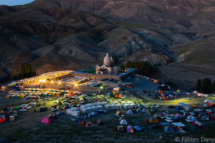
The Dzordzor chapel is usually closed, but in the two monasteries there live an old Kurd and Azeri guardian, respectively, who willingly open the church and guide you around. And there is a day in the year when the monastery of Saint Thaddeus comes to life again. On this day, the day of its holy patron a multitude of Armenians come together here from all around the world to celebrate Mass and having a feast with music and dance. Fabien Dany in the last year and Duško M Du Swami in this year were there and published their photos. Perhaps in the next year I will also manage to do so.

The medieval Armenian monastery of Saint Thaddeus in Northern Iran, on the feast of Saint Thaddeus